
Αρχείο:East Galicia and Volhynia 1939.png
Δεν διατίθεται υψηλότερη ανάλυση.
East_Galicia_and_Volhynia_1939.png (600 × 450 εικονοστοιχεία, μέγεθος αρχείου: 74 KB, τύπος MIME: image/png)
| Αυτό το αρχείο και η περιγραφή του προέρχονται από το Wikimedia Commons. Οι πληροφορίες από την σελίδα περιγραφής του εκεί εμφανίζονται παρακάτω. |
Σύνοψη
| Περιγραφή |
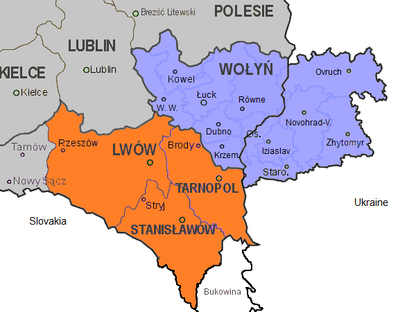
English: Map of the south-eastern part of Poland, within the borders of 1921-1939, as well as the eastern part of Volhynia. Highlighted in orange colour are the three Polish voivodeships of Lwów, Stanisławów, and Tarnopol which form the eastern part of Galicia. Areas in grey are other Polish voivodeships. In blue the Polish voivodeship of Wołyń, with the black border separating the eastern part which was part of the Ukrainian Soviet Socialist Republic. Both parts form the historical region of Volhynia. The internal borders in blue in Volhynia are the old pre-war districts with their capital towns.
Abbreviations of towns in Volhynia: |
| Ημερομηνία | |
| Πηγή | Έργο αυτού που το ανεβάζει |
| Δημιουργός | Gryffindor |
| άλλες εκδόσεις |
 |
Αδειοδότηση
Εγώ, ο κάτοχος των πνευματικών δικαιωμάτων αυτού του έργου, το δημοσιεύω δια του παρόντος υπό την εξής άδεια χρήσης:
| Το αρχείο αυτό έχει διατεθεί με Creative Commons CC0 1.0 Παγκόσμια Εκχώρηση Κοινού Κτήματος. | |
| Το πρόσωπο που συσχέτισε ένα έργο με αυτή την πράξη έχει απελευθερώσει αυτό το έργο στην δημόσια σφαίρα παραιτούμενος από όλα τα δικαιώματά του σε αυτό το έργο παγκοσμίως υπό τη νομοθεσία των πνευματικών δικαιωμάτων και όλα τα σχετικά ή παρεμφερή νόμιμα δικαιώματα που είχε στο έργο, στο εύρος που νόμος ορίζει. Έργα υπό την CC0 δεν χρειάζονται απόδοση. Όταν παραθέτετε το έργο, δε χρειάζεται να υπαινιχθείτε έγκριση από το συγγραφέα.
|
| Annotations | This image is annotated: View the annotations at Commons |
Ιστορικό αρχείου
Κλικάρετε σε μια ημερομηνία/ώρα για να δείτε το αρχείο όπως εμφανιζόταν εκείνη τη στιγμή.
| Ώρα/Ημερομ. | Μικρογραφία | Διαστάσεις | Χρήστης | Σχόλια | |
|---|---|---|---|---|---|
| τελευταία | 12:20, 14 Νοεμβρίου 2013 | | 600 × 450 (74 KB) | Gryffindor | {{Information |Description={{en|Map of the south-eastern part of Poland, within the borders of 1921-1939, as well as the eastern part of Volhynia. Highlighted in orange colour are the three Polish voivodeships of Lwów, Stanisławów, and Tarnopol whic... |
Συνδέσεις αρχείου
Τα παρακάτω λήμματα συνδέουν σε αυτό το αρχείο:
Καθολική χρήση αρχείου
Τα ακόλουθα άλλα wiki χρησιμοποιούν αυτό το αρχείο:
- Χρήση σε ca.wikipedia.org
- Χρήση σε cs.wikipedia.org
- Χρήση σε en.wikipedia.org
- Χρήση σε fy.wikipedia.org
- Χρήση σε gl.wikipedia.org
- Χρήση σε it.wikipedia.org
- Χρήση σε ka.wikipedia.org
- Χρήση σε pl.wikipedia.org
- Χρήση σε simple.wikipedia.org
- Χρήση σε sl.wikipedia.org
- Χρήση σε tt.wikipedia.org
- Χρήση σε vi.wikipedia.org