Μετάβαση στο περιεχόμενο

Αρχείο:Europe in 1345.png

Τα περιεχόμενα της σελίδας δεν υποστηρίζονται σε άλλες γλώσσες.
Αυτό το αρχείο προέρχεται από το Wikimedia Commons
Από τη Βικιπαίδεια, την ελεύθερη εγκυκλοπαίδεια

Εικόνα σε υψηλότερη ανάλυση (1.075 × 1.168 εικονοστοιχεία, μέγεθος αρχείου: 114 KB, τύπος MIME: image/png)

Σύνοψη

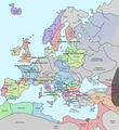
Περιγραφή A map of Europe in 1345, showing the location of events that took place in that year. The Black Plague's exact location in unknown, and the shaded area to the right represents rough scholarly estimates. It hit the Crimea in the following year.
Ημερομηνία
Πηγή self-made from Image:Europein1328.png with GIMP
Δημιουργός Teaandcrumpets
This historical map image could be re-created using vector graphics as an SVG file. This has several advantages; see Commons:Media for cleanup for more information. If an SVG form of this image is available, please upload it and afterwards replace this template with {{vector version available|new image name}}.


It is recommended to name the SVG file “Europe in 1345.svg”—then the template Vector version available (or Vva) does not need the new image name parameter.
Maps of the history of Europe
BCE
aC

Weichselian ice age (c. 113,000–9700) · Neolithic expansion (c. 7000–4500) · Middle Neolithic (c. 4500–4000) · Late Neolithic (c. 4000–3000) · Copper Age – Corded Ware culture (c. 2900–2350) · Copper Age – Bellbeaker culture (c. 2800–1800) · Early Bronze Age – Unetice culture (c. 2300–1600) · Late Bronze Age – Urnfield culture (c. 1300—750) · Migrations (c. 1000–100) · Hallstatt & La Tène cultures (c. 800–100) · Roman Republic (510–40) · 220 · 218 · 200 · 201–100 · 58 · 49 · 39 · 30 BCE–6 CE


CE
dC

14 · 14–37 · 60 · 60 · 69 · 80 · Migrations 100–500 · 117 · 117 · 125 · Migrations 150–774 · Economy 180 · 271 · 293–305 · 337 · 395 · c. 395 · 400 · 400 · 450 · 457–61 · 476 · 480 · Franks 481–814 · Early Slavs 500–700 · 500 · 526 · 526–600 · Christianisation to 600 · c. 550 · 650 · Pontic Steppe 650 · 665 · 800 · Vikings 800–1050 · 814 · 843–70 · 850 · 900 · 912 · 998 · 1000 · 1000 · 1054 · 1092 · First Crusade 1095–99 · 1097 · 1135 · 1142 · 1147–49 · 1190 · 1190 · 1250 · c. 1250 · 1301-1400 · 1301-1400 · 1328 · 1345 · Black Plague 1347–51 · 1360 · 1400 · Trade routes c. 1400 · 1430 · 1470 · 1490 · 1492 · 1500 · 1519 · 1550 · 1560 · Religion 1560 · Religion 1600 · Religion 1618 · 1618–48 · 1648 · 1683 · 1700 · 1701 · 1708 · 1714 · 1721 · 1725–30 · 1739–1740 · 1740 · 1748–66 · 1783–1792 · 1787 · 1787 · 1789 · 1799 · 1812 · 1812 · 1812 · 1812 · 1813 · 1815 · 1815 · 1815 · 1818 · Ottoman Empire 1830–1923 · 1848–49 · 1861 · 1867 · 1871 · 1878 · 1890 · 1905 · 1911 · 1914 · 1914 · 1919 · 1919–29 · 1923 · 1929 · 1930 · 1940 · 1941–42 · 1942–45 · Cold War 1947–91 · 1950 · 1993–2006 · 2006 to date

(this template: · view · discuss )

Αδειοδότηση

Public domain Εγώ, ο κάτοχος των πνευματικών δικαιωμάτων αυτού του έργου, δημοσιεύω αυτό το έργο ως κοινό κτήμα. Αυτό ισχύει σε παγκόσμια κλίμακα.
Σε ορισμένες χώρες αυτό μπορεί να μην είναι νομικά εφικτό. Αν ναι:
Παραχωρώ σε οποιονδήποτε το δικαίωμα να χρησιμοποιήσει αυτό το έργο "για οποιονδήποτε σκοπό", χωρίς κανέναν όρο, εκτός και αν τέτοιοι όροι τίθενται από την νομοθεσία

Λεζάντες

Δεν ορίστηκε λεζάντα

Items portrayed in this file

απεικονίζει

Ιστορικό αρχείου

Κλικάρετε σε μια ημερομηνία/ώρα για να δείτε το αρχείο όπως εμφανιζόταν εκείνη τη στιγμή.

Ώρα/Ημερομ.ΜικρογραφίαΔιαστάσειςΧρήστηςΣχόλια
τελευταία19:31, 10 Μαΐου 2020Μικρογραφία για την έκδοση της 19:31, 10 Μαΐου 20201.075 × 1.168 (114 KB)Santasa99Corrections per Euroatlas - Historical Maps, http://www.euratlas.net/history/europe/1300/index.html Euratlas Periodis Web - Map of Europe in Year 1300
12:58, 24 Δεκεμβρίου 2017Μικρογραφία για την έκδοση της 12:58, 24 Δεκεμβρίου 20171.075 × 1.168 (289 KB)Trey KincaidChanged Sicily who had his own kingdom
19:30, 1 Ιουλίου 2012Μικρογραφία για την έκδοση της 19:30, 1 Ιουλίου 20121.075 × 1.168 (282 KB)Ludde23Changed Estonia from the red color of Sweden to the yellow color of Denmark, since Estonia was not Swedish at this time, but belonged to Denmark until 1346.
21:34, 24 Απριλίου 2009Μικρογραφία για την έκδοση της 21:34, 24 Απριλίου 20091.075 × 1.168 (112 KB)Alex:DBorders corrected
18:02, 15 Νοεμβρίου 2007Μικρογραφία για την έκδοση της 18:02, 15 Νοεμβρίου 20071.075 × 1.168 (110 KB)Teaandcrumpets(changed notre dame marker)
23:03, 13 Νοεμβρίου 2007Μικρογραφία για την έκδοση της 23:03, 13 Νοεμβρίου 20071.075 × 1.168 (113 KB)Teaandcrumpets{{Information |Description= A map of Europe in 1345, showing the location of events that took place in that year. |Source=self-made from Image:Europein1328.png with GIMP |Date= 13 Nov 2007 |Author= Teaandcrumpets |Permission=

Δεν υπάρχουν σελίδες που συνδέουν σε αυτό το αρχείο.

Καθολική χρήση αρχείου

Τα ακόλουθα άλλα wiki χρησιμοποιούν αυτό το αρχείο:

Μεταδεδομένα